Wiltshire: St Mary’s, Old Dilton – At the Mercy of Mechanisation
This 4.7km route will lead you on a gentle journey of discovery into the industry which brought about the Church's rise and fall, the histories of a multitude of buildings besides the Church itself and its strikingly beautiful replacement.
This route can also be followed for free online at Plotaroute.com. or as a PDF here.
Summary:
A walking route which centres on the Church of the Blessed Virgin Mary in Old Dilton. Starting and finishing at the request station of Dilton Marsh, this 4.7km route will lead you on a gentle journey of discovery into the industry which brought about the Church's rise and fall, the histories of a multitude of buildings besides the Church itself and its strikingly beautiful replacement. This walk should take between 1-2 hours to complete, taking into account a visit to the Church.
Trains call at Dilton Marsh at roughly two-hour intervals in each direction, although it is advisable to check the times in advance. The station is a request stop - you must tell the train guard that you are getting off there in advance while if you want to get on a train from the platform, you need to hold out your hand to hail it, as you would with a bus. All in all, this will hopefully be a pleasant little walk full of quaint sights, gentle terrain and fascinating history!
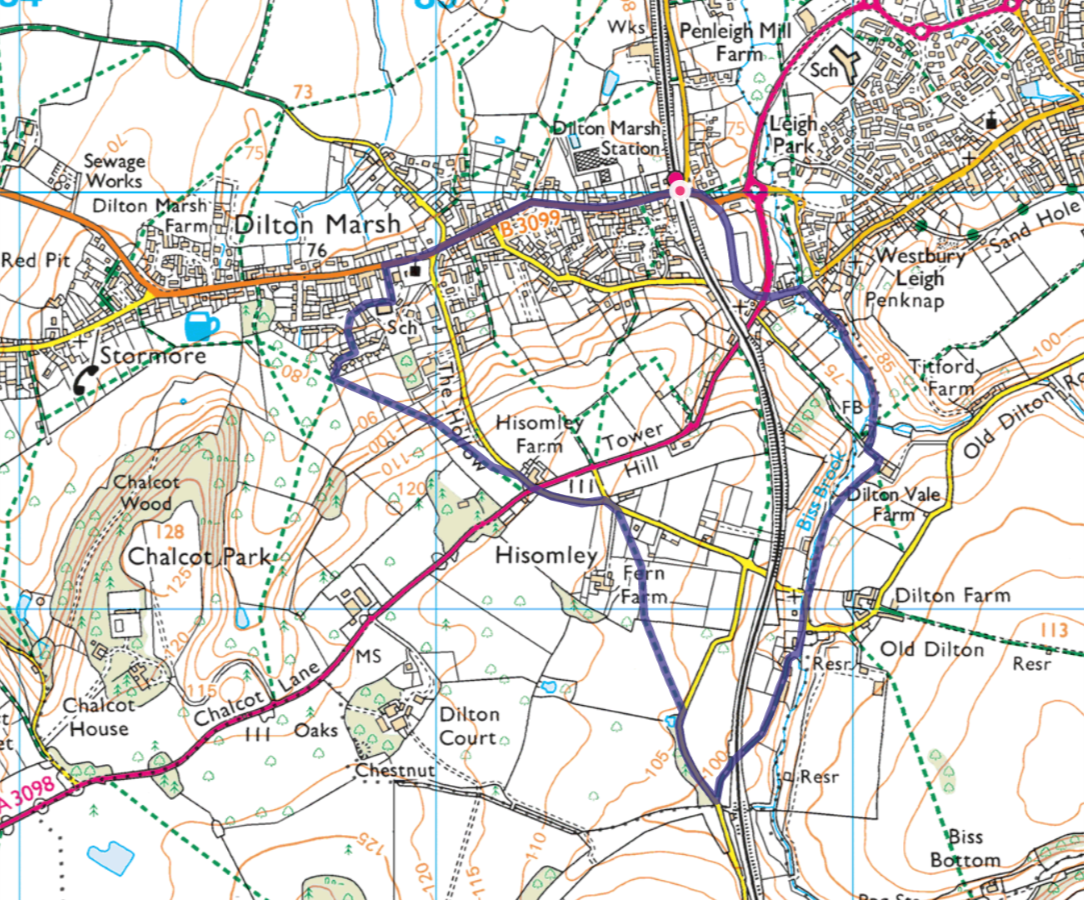
Regular Route – 4.6km (2.9 miles) with stiles
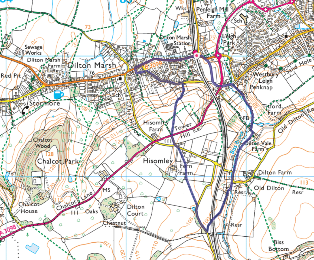
Accessible Route – 4.3km (2.7 miles) without stiles
Directions (Diversion for accessible route in italics)
1. Welcome to this walk exploring the Church of the Blessed Virgin Mary in Old Dilton, and its story and surroundings. We start here at the tiny halt of Dilton Marsh. Built for the village of the same name in 1937, it is the least used station in Wiltshire and the county's only request stop. We'll discover more about the village a little later, but first we will turn east along the B3099 before shortly taking the first right onto High Street at the mini roundabout.
2. The building to your right is Penknap Providence Church. This building of 1810 serves the Baptists of the local community who were present in Westbury Leigh, just to your east from the 17th century onwards. Another Baptist church of 1797 is located in Westbury Leigh itself which also boasts an Anglican church of the 1870s.
The fact that these places of worship were being built at a time when St. Mary's in Old Dilton fell into disuse show that the local population had shifted northwards since the old church's construction in the 14th and 15th centuries. We will pass the church which directly replaced St. Mary's later in the walk but firstly we'll discover why it was abandoned...
3. Carefully cross the A3098.
4. The imposing Bridge Farmhouse, with a stone clad 18th century front range masking a 17th century rear wing, was once the Apple Tree Inn. It would have catered for the workers of the thriving local cloth industry, which was based at a series of mills straddling Biss Brook, a stream immediately beyond the former pub.
The last of these mills closed in 1969 though their heyday had ended almost a century before. Many have been demolished, though there are some survivors which we will discover in due course. These buildings themselves however, had played a part in St. Mary's becoming abandoned.
5. Turn right down the appropriately named Mill Lane to discover one of the survivors, namely the 19th century Millstream House, a white-rendered brick building on the left-hand side of the road.
6. Continue through the gate and on to the public footpath.
7. Head over the stile then follow the path as it turns left then heads on around Dilton Vale Farmhouse.
8. Although Dilton Vale Farmhouse to your right has had numerous additions over the centuries, it started off life as a late 17th century fulling mill and spinning factory. The millhouse itself was on the site of the modern garage, though fragments of its timber framing can still be seen at the farm building's southeastern corner.
Along with a general decline in the woolen industry this area depended on during the 17th century, the economic outlook for labourers was further dampened by the increasing mechanisation of the industry, as was evident in these mills and factories. As such, the inhabitants of Old Dilton, seeking their own financial stability (we will discover more about the medieval village soon) moved northwest to a marshy area of common land which would develop into a thriving handloom centre for the following two centuries - Dilton Marsh.
9. Turn left until just before the farm buildings, where the sign will guide you to the right. This path will take you down to the brook again.
10. You are now approaching the village of Old Dilton, or simply Dilton as it was known in the medieval era. The name is thought to have originated as Dyllan-tun, an Old English name meaning Dylla's Farmstead. This name implies a Saxon origin for the settlement, though exactly who Dylla was is now lost in time. By the fourteenth century, Dilton had grown into a thriving wool-producing village, with six mills in its vicinity. Prior to mechanisation, these buildings were integral to the working life of the village. With the exception of the church, the medieval buildings are long gone with the modern houses and farms dating from the 19th century.
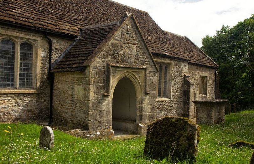
11. At this point, you have reached St. Mary's itself so take a look inside! The keyholder is nearby, with instructions provided on the church door if it is locked. A detailed description of the church and its history is provided in its guidebook and its online audio tour though some of the building's features are noted below.
Just to the south of the church is a chest tomb, which although illegible, is thought to date from the 17th century and it officially is a Grade II listed building. The church itself has the highest rank of Grade I and its oldest part is actually the porch. This dates from the early 14th century and along with the pair of windows in the south-west of the chancel (just left of the small priest's door) is thought to date from a previous church on this site. The rest of the building was constructed in the early 15th century and the outside of the building has various small crosses etched into it. These are rare examples of medieval graffiti, though while the main door is medieval, the carvings of this were made by US servicemen during the Second World War.
The interior fittings of the Church are covered in detail in the guidebook but particularly noteworthy are the galleries and box pews. Box pews came about following the Protestant Reformation as parishioners were expected to sit and listen to the word of God from 1569, twenty years after services switched from being said in Latin to English. Previously, only the lord of the manor, visiting dignitaries and churchwardens would have sat, the rest of the congregation standing. Box pews were expected to be hired out or owned by the individual families within the parish and could be left in wills, and in some cases even furnished with fireplaces and curtains, with the surrounding walls sometimes too high to see the alter from! St. Mary's fittings date from the 18th century, although some booths incorporate older medieval benches. Box pews fell out of fashion in the mid-nineteenth century but have survived here as the church ceased to be regularly used at the same time (1844). The galleries, like that which overlooks the altar to its left were for the use of the local nobility, though this one was used as a schoolroom from the 19th-20th centuries, showing how the building did not fall into complete disuse. A 19th century fireplace was inserted into this room for this purpose, paralleled in the vestry below.
The church's redundancy for regular services after 1844 (when a new church was built for the larger community at Dilton Marsh) helped save it from the Victorian-era restoration which irrevocably altered many other medieval places of worship, with only two services a year there being held by the 20th century. It was formally declared redundant in 1973 and vested in the care of the Churches Conservation Trust (then called the Redundant Churches Fund) the following year. Its liturgical life continues through its use for an Advent Carol Service each year however.
12. After visiting the church (donations would be very welcome!) continue down Old Dilton Road before forking to the right by the white house to head along the lane.
13. Continue heading south, now following the public bridleway. Shortly after passing under the railway bridge and alongside a few houses, you will come to a road.
14. Turn right and head along the road for about 250m until seeing the sign for the public footpath on your left.
15. Follow the footpath across the fields, passing through several gates and catching sight of the late 18th century Hisomley Farmhouse to your left.
16. Once reaching the road, head left a short distance to the road junction.
17. You can choose here whether to take the main route by heading left along a route which will pass over several more stiles. Alternatively, you can head right to take a diversion over fields separated by gates (see red section below). Both routes will reunite near the Church of the Holy Trinity, in Dilton Marsh.
18. Head down The Hollow for a short distance after crossing the A road before taking the first public footpath on the left. Note that if you’re using an Ordnance Survey map, it will imply that the footpath entrance is directly opposite you, not down The Hollow, upon reaching the A road but this is not the case; plotaroute has the correct entrance spot.
19. As you can gather from the descent you've just navigated, this area was indeed a marsh lowland area in the 17th century prior to its development. Some of the buildings in 'Dilton's Marsh' as it was initially known date from the 18th and 19th centuries, and we will shortly see the impressive building which replaced St. Mary's in Old Dilton. Bear right along Woodland View.
20. At the junction, turn left onto the Avenue.
21. Head diagonally right across the car park to find the small alleyway between the houses. Follow this path to Dilton Marsh Primary School.
22. Turn left and head up to the High Street.
23. In 1841, the village of Dilton Marsh was home to some 2,000 people and a new larger and more convenient church was evidently necessary. The funds raised included a substantial sum by the local Phipps family, whose venture into the handloom industry proved profitable enough for them to buy Chalcot House, a large manor to the south of the village. The total cost of the grand Neo-Norman Church of the Holy Trinity, its surrounding gates and churchyards, the schoolhouse (the stone building you are currently adjacent to) and the vicarage (tucked away to the south of the church) was £3,264 upon completion in 1844. This is over £425,000 in today's money.
The school was funded by the Church of England and has now outgrown its original building, moving south to its present site. The church, filled with colour, paintings, mosaics, early electrical light fittings and Victorian stained glass had a capacity of 600 upon its completion. It truly dominates the surrounding buildings and is well worth a look inside!
The main route continues in black text below the accessible directions.
------------------------------------------------------------------------------------------------------------------------------------------
24. After crossing the A road, take the footpath forking to the right across the fields.
25. As you can gather from the descent you've just navigated, this area was indeed a marsh lowland area in the 17th century prior to its development. Some of the buildings in 'Dilton's Marsh' as it was initially known date from the 18th and 19th centuries, and we will shortly see the impressive building which replaced St. Mary's in Old Dilton. Continue to follow the footpath through the trees until you emerge onto Petticoat Lane.
26. Turn left onto Whitecroft and follow this road as it bends onto the High Street.
27. If you turn left here, you will come across Holy Trinity Church, the building which replaced St. Mary's. In 1841, the village of Dilton Marsh was home to some 2,000 people and a new larger and more convenient church was evidently necessary. The funds raised included a substantial sum by the local Phipps family, whose venture into the handloom industry proved profitable enough for them to buy Chalcot House, a large manor to the south of the village. The total cost of the grand Neo-Norman Church of the Holy Trinity, its surrounding gates and churchyards, the schoolhouse (the stone building fronting the street beyond the church) and the vicarage (tucked away to the south of the church) was £3,264 upon completion in 1844. This is over £425,000 in today's money.
The school was funded by the Church of England and has now outgrown its original building, moving south to its present site. The church, filled with colour, paintings, mosaics, early electrical light fittings and Victorian stained glass had a capacity of 600 upon its completion. It truly dominates the surrounding buildings and is well worth a look inside!
The directions for the final section of the walk is continued in normal text below.
-------------------------------------------------------------------------------------------------------------------------------
28. You can head east to follow the High Street back to the station where the walk will end. The oldest building along this road may be Fairfield Farmhouse, dated to 1764 (350m beyond the church, just to the east of a modern garden centre on the road’s north side). 100m further beyond this, again on the north side of the street is an early 19th century milestone, a record of the turnpiking of the road from Bath to Westbury, which helped the village grow to a significant enough size to eventually warrant a station, albeit one where the trains have to be hailed to make them stop.
On that note, we hope you have enjoyed this walk and thank you if you have made a donation - St. Mary's costs £4,706 per year to maintain, so your generosity allows us to keep this beautiful place of worship open for the public to enjoy.